The rumble of your engine echoes off canyon walls as you navigate a winding trail through spectacular terrain. Miles of open landscape stretch ahead, inviting exploration. But beneath this freedom lies a complex web of land designations, access rules, and management agencies that every off-road adventurer should understand.
As outdoor recreation continues to grow—with off-road vehicle registration increasing by over 40% in the past decade—the intersection of public land access and responsible recreation has never been more critical. Understanding how to navigate this landscape isn’t just about following rules; it’s about preserving access for future generations of adventurers.
The public lands landscape
America’s public lands represent one of the world’s greatest outdoor recreation resources. Spanning over 640 million acres—roughly 28% of the United States—these lands are managed by various federal, state, and local agencies, each with distinct missions and access policies.
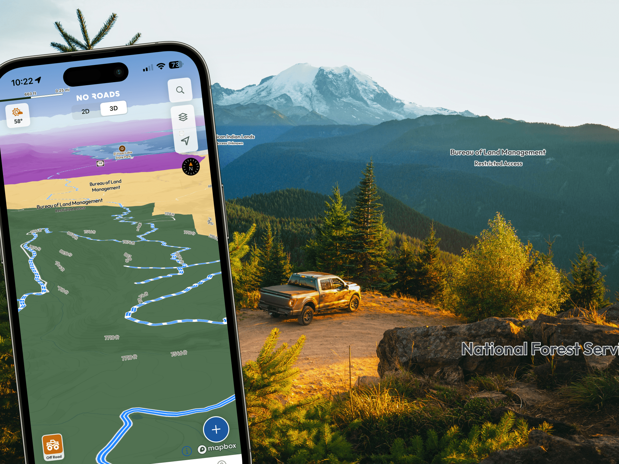
The complexity can be overwhelming. A single off-road route might cross Bureau of Land Management (BLM) territory, enter a National Forest, skirt a wilderness boundary, and pass through state trust lands—each transition potentially changing what’s allowed and what’s not.
Federal land management agencies and their missions:
- Bureau of Land Management: Manages lands for multiple uses including recreation, often with the most permissive off-road access
- U.S. Forest Service: Balances recreation with forest conservation, typically allowing designated route travel
- National Park Service: Prioritizes preservation, generally restricting off-road travel to established roads
- U.S. Fish and Wildlife Service: Focuses on wildlife protection, with varying but often limited motorized access
Understanding these different philosophies helps explain why access rules vary so dramatically between adjacent properties.

The evolution of access policies
Trail access wasn’t always this complicated. In the early days of motorized recreation, most public lands operated under an informal “go anywhere” philosophy. However, increasing recreation pressure, environmental concerns, and conflicts between user groups led to more structured management approaches.
The 1976 Federal Land Policy and Management Act marked a turning point, requiring systematic planning for public land use. Executive Order 11644 in 1972 first addressed off-road vehicle management, leading to the development of designated route systems that form the backbone of today’s trail networks.
This evolution reflects a broader shift in outdoor recreation management—from unlimited access toward sustainable use models that balance recreation with conservation. While this sometimes means fewer open areas, it also means more predictable, well-maintained trail systems that can support long-term recreational use.
Understanding land designations and access levels
Modern public land management relies on multiple classification systems that determine allowed activities. Understanding these systems helps adventurers interpret what they’re seeing and plan accordingly.
Management Agency Classifications: The most fundamental distinction is which agency manages the land, as each has different missions and typical access policies:
- Forest Service: Generally allows designated route travel with extensive trail networks
- Bureau of Land Management: Often provides the most permissive off-road access policies
- National Park Service: Typically restricts motorized travel to established roads only
- Department of Defense: Access varies widely depending on facility and current operations
- State/Territory and Local/Regional: Rules vary significantly by jurisdiction
- Native American: Sovereign lands with their own access regulations
- Private/Other: Requires landowner permission for access
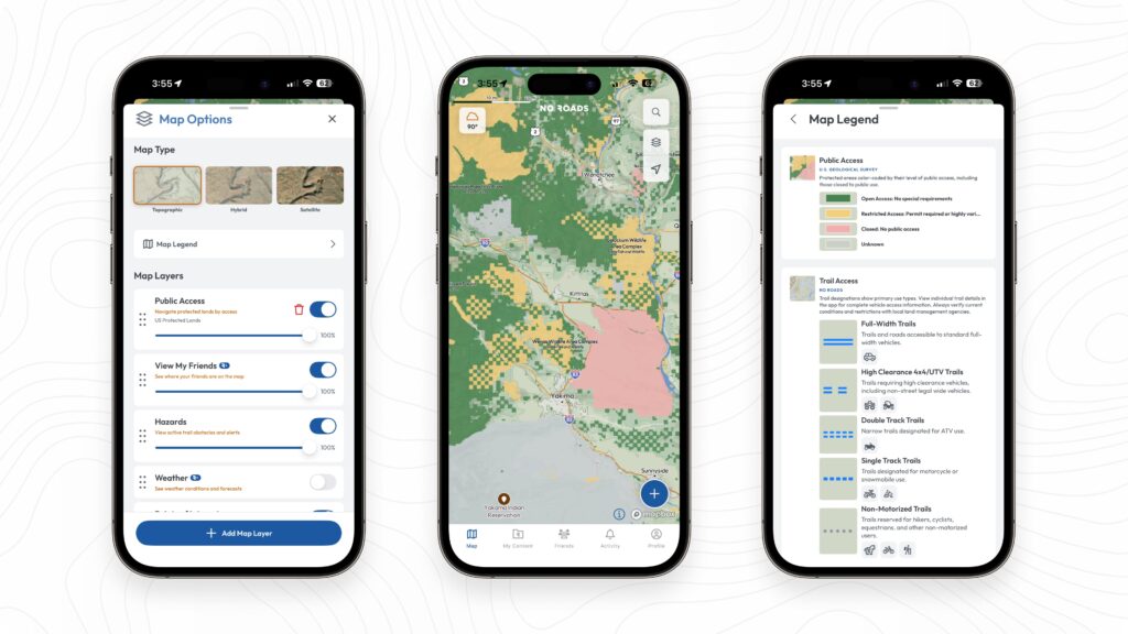
Public Access Categories: Beyond agency management, lands are classified by their accessibility level:
- Open Access: No special requirements for public use
- Restricted Access: May require permits or have highly variable access conditions
- Closed: No public access allowed
Conservation Status Classifications: Additional layers show environmental protection levels that can affect recreation rules:
- IUCN Categories: International standards ranging from strict nature reserves to areas allowing sustainable resource use
- GAP Status: Measures ecological protection levels from fully protected ecosystems to areas with no known protections
These multiple classification systems often overlap, creating complex access scenarios where understanding all relevant designations becomes crucial for trip planning.
Technology meets traditional knowledge
Traditionally, understanding land access required studying paper maps, agency websites, and local knowledge. While these remain valuable, technology is transforming how adventurers research and plan their trips.
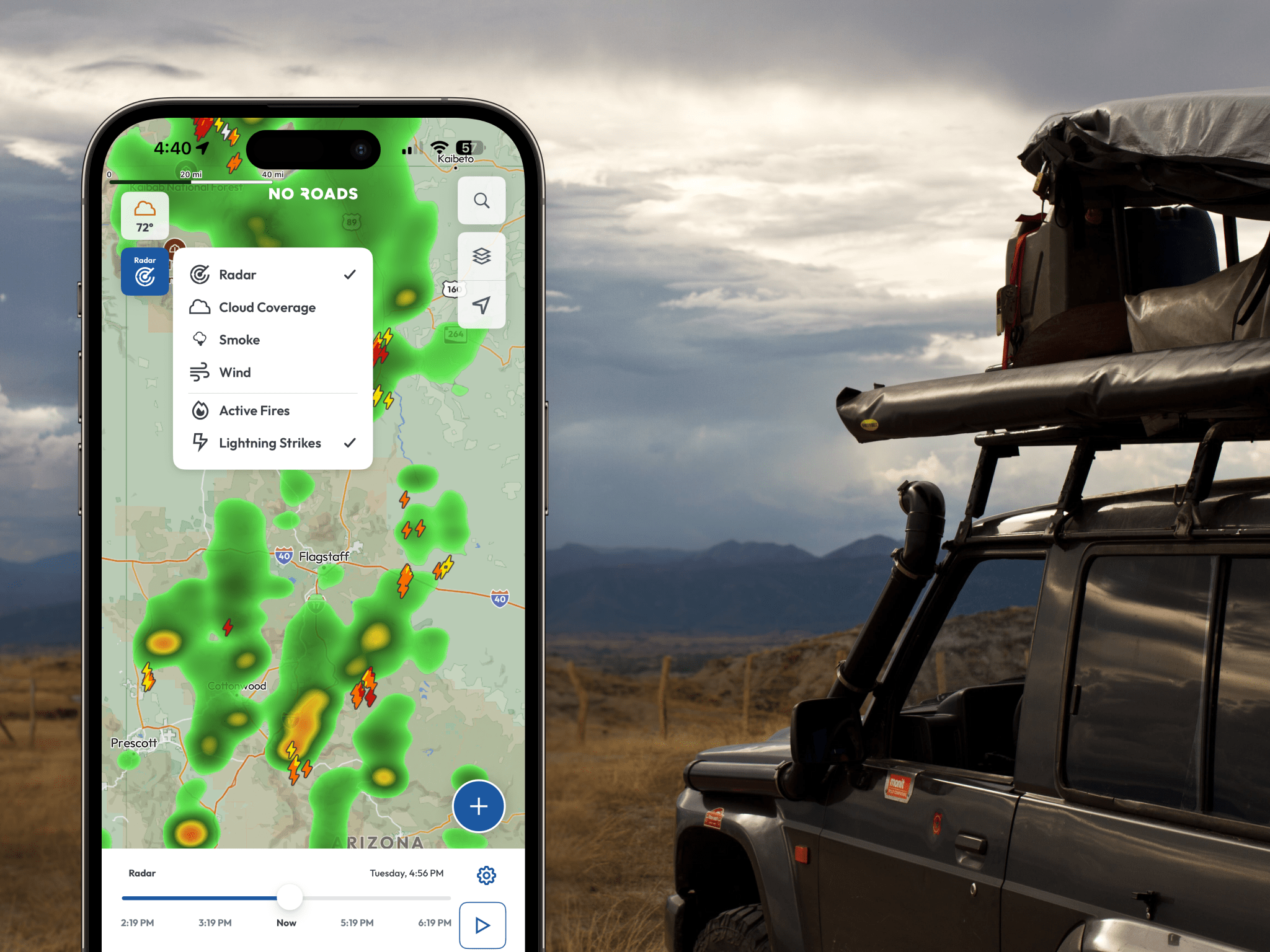
Modern mapping platforms can overlay land ownership boundaries, management designations, and access restrictions in real-time. No Roads’ Protected Lands layers, for example, provide color-coded visualization of managing agencies, public access levels, conservation status, and IUCN categories, making it easier to understand what you’re looking at and what rules apply.
Beyond just showing boundaries, comprehensive mapping apps like No Roads integrate community knowledge with official data. Trail ratings, hazard reports, and local insights from fellow adventurers complement the regulatory information, creating a complete picture for trip planning.
This technological approach doesn’t replace the need for current information—land use decisions change, seasonal closures shift, and emergency restrictions can appear suddenly. However, it provides a crucial foundation for trip planning and helps adventurers ask the right questions when contacting local agencies.
The responsible recreation imperative
With great access comes great responsibility. The off-road community’s future access depends largely on how well current users demonstrate responsible recreation practices. High-profile conflicts, environmental damage, or safety incidents can quickly lead to access restrictions that affect everyone.
Tread Lightly principles for off-road exploration:
Travel responsibly on designated routes only. Resist the temptation to create new trails or shortcuts, even when existing routes seem unnecessarily circuitous.
Respect the rights of others including private landowners, other recreationists, and wildlife. Your adventure shouldn’t diminish someone else’s experience or safety.
Educate yourself about the areas you visit. Understanding local regulations, seasonal restrictions, and environmental sensitivities demonstrates respect for the land and its managers. Tools like No Roads make this research easier by providing detailed land management information and community insights in one place.
Avoid sensitive areas and activities that could cause lasting environmental damage. Some terrain that looks driveable may be ecologically fragile or culturally significant.
Do your part by leaving areas better than you found them. Pack out all trash, repair damage when possible, and report serious problems to land managers.
These principles aren’t just idealistic guidelines—they’re practical strategies for maintaining access. Land managers take note of user behavior, and consistent responsible use strengthens the case for continued recreational access.
No Roads has partnered with the Overland Expo Foundation to embed their “Overlanding Responsibly” charter directly in the app under settings. This resource provides comprehensive guidance for ethical outdoor recreation and demonstrates the industry’s commitment to sustainable trail use.

Industry trends shaping access
Several significant trends are reshaping the public lands access landscape:
Increasing recreation pressure: Popular areas are seeing unprecedented use levels, leading to infrastructure strain and management challenges. Some areas are implementing reservation systems or capacity limits.
Urban interface growth: As communities expand toward public lands, new conflicts arise over noise, traffic, and differing land use expectations.
Technology-driven discovery: Social media and mapping apps are directing more people to previously obscure locations, sometimes overwhelming areas not designed for heavy use.
Climate change impacts: Changing weather patterns affect seasonal access windows and trail conditions, requiring more flexible management approaches.
Generational shifts: New recreationists often bring different expectations and comfort levels with technology-based trip planning versus traditional methods.
These trends suggest that future access management will likely involve more sophisticated tools, dynamic restrictions, and collaborative approaches between agencies and user communities.
Planning for successful adventures
Successful off-road adventures begin with thorough research. Understanding land designations, current restrictions, and seasonal considerations prevents disappointment and ensures compliance with regulations.
Essential pre-trip research:
- Verify current access status through agency websites or direct contact
- Check for seasonal closures related to wildlife protection, fire restrictions, or weather conditions
- Understand permit requirements for certain areas or activities
- Identify alternative routes in case primary plans change
- Know emergency contact information for the areas you’ll visit
Modern tools like No Roads make this research more efficient by consolidating land management data, community insights, and trail information in one platform. However, they don’t eliminate the need for current, authoritative information from land management agencies, who remain the ultimate source for access decisions and restrictions.

The future of trail access
The future of off-road access on public lands will likely be shaped by how well the recreation community demonstrates its commitment to responsible use. Successful models often involve partnerships between agencies, user groups, and local communities.
Education plays a crucial role. As the recreation community grows and diversifies, ensuring that new participants understand both opportunities and responsibilities becomes increasingly important.
Technology will continue to evolve, offering new tools for trip planning, real-time communication, and impact monitoring. However, the fundamental challenge remains balancing recreational access with conservation goals and multiple use mandates.
The key to maintaining and potentially expanding access lies in demonstrating that off-road recreation can coexist sustainably with other land uses and conservation objectives. This requires individual responsibility from every adventurer and collective action from the broader community.
Your role in preserving access
Every off-road adventure is an opportunity to demonstrate responsible recreation. The trails you use today exist because previous generations of adventurers worked to establish and maintain access. Preserving these opportunities for future explorers requires the same commitment from today’s community.
Understanding public lands, respecting regulations, and practicing Tread Lightly principles aren’t just legal requirements—they’re investments in the future of off-road recreation. The spectacular landscapes that draw us to these adventures deserve our best stewardship efforts.
Whether you’re planning your first off-road adventure or your hundredth, taking time to understand the land you’re exploring enhances both safety and enjoyment while supporting continued access for the entire community.
Any terrain. Any adventure. No limits. No Roads.
Explore responsibly with detailed public land information. No Roads+ subscribers can access Protected Lands layers showing agency boundaries and management designations.